Florence 2018

WDR65

Enlightened
Joined
Feb 3, 2005
Messages
804
Location
Southeastern, NC
Up to 40" of rain...I just can't imagine that!

Me either, I've seen 22" from Hurricane Floyd but never 40". I feel confident if its just above 22" as I've seen it when the ground was saturated from previous storms and this time we're very dry and the ditches, creeks and rivers are low. That will help, but if this thing sits here for three days I don't have anything to compare it to.

I do feel for the first responders and the lineman. They're going to be busy and I hope they stay safe.
 

WDR65

Enlightened
Joined
Feb 3, 2005
Messages
804
Location
Southeastern, NC
poop.
Good luck, it feels unbelievable smug sitting over here, sorry.
P


Peter,
Thanks for the sentiment and I imagine others would echo that. It's just part of life on the coast. I'm sure you're area has similar weather or natural events that happen. It's the not knowing what is going to happen that is the worst for these slow movers.

Dudley
 

WDR65

Enlightened
Joined
Feb 3, 2005
Messages
804
Location
Southeastern, NC
For folks along the SC and GA coasts, who haven't paid attention....

Things have changed. Looks like as far south as Georgia is in the potential influence now and instead of Cape Fear NC being the bullseye, Myrtle Beach SC.... perhaps Charleston may have become the target.

Bykfixer,
Where are you seeing this? I've stopped prepping for a few minutes and am watching the evening news they're telling us that it's going to park off or around Cape Fear for up to three days. We're going to be on the northeast side just outside the eyewall if it follows the track I just saw.
 

mcm308

Enlightened
Joined
May 19, 2009
Messages
359


This will give you a good idea where shes going. I hope your not close to the coast on that NE quadrant. The NE quad is the onshore flow and surge
 

bykfixer

Flashaholic
Joined
Aug 9, 2015
Messages
20,482
Location
Dust in the Wind
IMG_20180912_190144.jpg

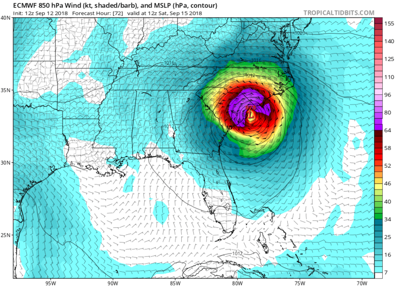
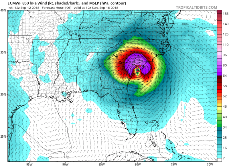
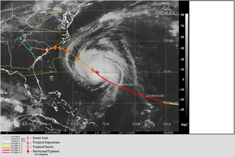
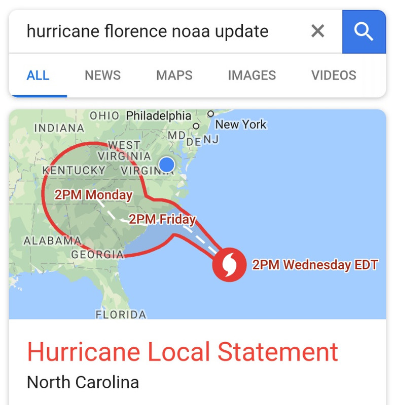
This was noaa at 2pm

I've been watching clouds pass over the last 2 days to get a guage on where objects may go if/when they became airborne where I work.

Lots of plywood, sheets of metal, porta-johns etc on a bridge project and not everything can be stored inside. So we kinda do the boyscout thing and try to place objects where if they become airborne they don't fly across the highway. We also try to guess where water will build up and prevent the highway from being flooded by our construction related stuff.

I've been on a few of these and they usually get shut down a day or two before the storm arrives. Gives the workers a chance to do stuff at home to lessen their impact as much as possible. The place I work now was evacuated starting yesterday so we couldn't wait on the tv drama show to tell us where and when. We have to do our own advance meteorology to a degree. And believe it or not watching clouds way out front of the big storm is a great predictor. Old school, Thomas Jefferson era stuff.

Monday for example, it appeared that Cape Fear was the bullseye. Yesterday too. Today a young up-n-comer noticed a change in the direction the clouds were moving and asked me if I'd noticed. I smiled not telling him I had gotten an update at 6am and said "looks like Myrtle Beach may be the bullseye now". We watched the clouds and he said "yeah, I agree".... shortly after that a boss pulls up and says "hey, looks like we'll be spared, the radio says it's moving south". lol. Everybody left on the project were ready to leave at noon, but were doing some last minute preparations and giving the place that one last look before heading out.

We're near Va Beach where it was supposed to get ugly tomorrow morning into Friday. Now it's predicted that area might get some 45mph gusts and I get an, unexpected vacation. lol.
 
Last edited:

mcm308

Enlightened
Joined
May 19, 2009
Messages
359
I read that a 100 people are refusing to leave the mandatory evacuation area. I don't understand why someone would allow themselves to remain in harms way. :shakehead Why risk it?

~ Chance

I heard 200 are staying on the outer banks...[emoji85]
 

WDR65

Enlightened
Joined
Feb 3, 2005
Messages
804
Location
Southeastern, NC
Bykfixer,
I apologize that was a dumb question on my part. I'm running on fumes and had seen that track, I was just focused on the track for the next couple of days. It meanders around my area, maybe not even making landfall.


MCM308,
I'm about twenty miles inland from where some of the worst surge is supposed to happen. My family has vacation property on Topsail Island but none of us have ever tried to stay there through a hurricane. I've seen the aftermath of a couple up close and it's not a pretty sight.


Chauncey Gardiner,
I don't agree with their decisions but I understand why some are staying. It's sad that most of them don't realize that there is very little they can do to change the situation during the storm, even when they are present.


Anyway, sorry for using this thread as a bit of blog. I've enjoyed talking about it a little bit though and I'm sure some other members are about to be affected by this too and hopefully they'll chime in soon.


As for me I'm staying put for now, they just downgraded it to a category two which gives me some hope that we won't see as bad of wind damage as the initial predictions. Its still quiet here and we're not supposed to see even tropical storm force winds until tomorrow morning. My parents are going to make their decision in the morning and while that might be a whirlwind to pack them and get them out of here that will be a relief in other ways. I'm going to continue posting as long as I have internet and maybe even after on 4G. All depends on how long the towers stay on this time. I'll probably have a few observations on lighting to add as well.
 

bykfixer

Flashaholic
Joined
Aug 9, 2015
Messages
20,482
Location
Dust in the Wind
WDR65,

I don't see any reason for you to apologize. May the Lord keep you and yours from harm.

~ CG

Agreed.

My sister lives on the outter banks at the northern end and is staying. They've lived there since the 80's and know all the back roads to avoid traffic if a last minute skee-daddle is required. When they lived on Wanchees (spelling?) they split every time the alarm rang out. But where they live now is much higher and much better buffered.

Btw, I had made that post WDR hoping that word had gotten out, but just incase any CPFr's were checking the site and had not heard.

Now it's a Cat 2.
IMG_20170908_123716.jpg
 

markr6

Flashaholic
Joined
Jul 16, 2012
Messages
9,258
Just echoing what I said earlier...the "cat #" stuff is a horrible thing to put out to the public IMO. "It weakened" or "now it's a 2". So the 110 mph wind instead of 113mph makes it a walk in the park?

For tornadoes, which are rated after the fact, makes sense since you want some way to quantify it. But with hurricanes, people focus too much on that one number and wind instead of ALL the (more damaging) aspects that go along with it.
 

scout24

Flashaholic
Joined
Dec 23, 2008
Messages
8,869
Location
Penn's Woods
I spoke to my Stepfather yesterday, he and his girlfriend are staying. 1.7 miles from the shore. Fingers crossed... I did like the FEMA director's comparison of the storm categories- "Which would you rather be hit with- a train or a cement truck?"
 

WDR65

Enlightened
Joined
Feb 3, 2005
Messages
804
Location
Southeastern, NC
Just echoing what I said earlier...the "cat #" stuff is a horrible thing to put out to the public IMO. "It weakened" or "now it's a 2". So the 110 mph wind instead of 113mph makes it a walk in the park?

For tornadoes, which are rated after the fact, makes sense since you want some way to quantify it. But with hurricanes, people focus too much on that one number and wind instead of ALL the (more damaging) aspects that go along with it.

I understand what you're saying. I've heard several people say things about it dropping below a category three and being fairly relieved. They don't seem to realize that the difference between a category two and three is only a few miles per hour of windspeed.

Perhaps quantifying the storms differently would be a help. The last storm that hit us was Hurricane Matthew and it only brushed my area yet it caused catastrophic flooding.

I will say that the wind is my primary concern and that of my parents, trees coming down have been our primary problems in the past. Flooding is becoming a secondary and we have a general plan to get out though the areas we live in are on fairly high ground and have never seen it flood to the point of needing to leave.
 

WDR65

Enlightened
Joined
Feb 3, 2005
Messages
804
Location
Southeastern, NC
I spoke to my Stepfather yesterday, he and his girlfriend are staying. 1.7 miles from the shore. Fingers crossed... I did like the FEMA director's comparison of the storm categories- "Which would you rather be hit with- a train or a cement truck?"

What area are they in Scout24? Some places are pretty high that far inland, there are high bluffs on a lot of the intercoastal waterway her locally.


That's pretty good about the FEMA director.
 
Last edited:

WDR65

Enlightened
Joined
Feb 3, 2005
Messages
804
Location
Southeastern, NC
We still have power as of right now, though other areas of my county have lost it. Just had a late lunch and have hunkered down for now. Enjoying the AC and internet as long it lasts.

My wife has been checking facebook and the island to east of us is getting some surge already. Just heard that her uncle's brother is going to ride it out along the waterway in his mother's home. They own a restaurant on Topsail Island and I imagine he's trying to keep a close eye on all of it. I don't think that's the smartest way to do it but I'm trying to do the same thing here so I understand his reasoning.

The wind is really picking up as I'm typing this. Duke Energy has done a good job of vegetation removal along the right of ways over the past few years but they can't exactly clear hundreds of feet away from the lines, though that would be nice.


An interesting little note, one weather channel reporter that's about 75 miles north of us right now is wearing what I think is a baseball helmet. It makes sense but I've never seen anyone do that before.
 

AZPops

Flashlight Enthusiast
Joined
Jul 9, 2011
Messages
1,640
One of the guys on another forum posted this link to windy.com; https://www.windy.com/?33.605,-76.816,6

It shows exactly what the Hurricane is doing (it's a color coded overhead map, showing wind direction, rain fall amounts, etc.). You'all be safe!

Pops
 
Last edited:
Top