You are using an out of date browser. It may not display this or other websites correctly.
You should upgrade or use an alternative browser.
You should upgrade or use an alternative browser.
GPS info needed.
- Thread starter DaveG
- Start date
 Help Support Candle Power Flashlight Forum
It's a solid unit. The price is good. Tomtom and Garmin are the market leaders and typically get the best reviews. I didn't like the mount but it works well for almost everyone.
I know nothing about them,how is the TomTom 340XL?Just picked up one for a gift,got it for $115. looked like a good deal to me.Any info pro or con is a help.
TooManyGizmos
Flashlight Enthusiast
Read some reviews of those two makers .
At one time , TomTom did not work well in some areas of Florida.
That made me think Garmin would be better , If I ever get one.
.
At one time , TomTom did not work well in some areas of Florida.
That made me think Garmin would be better , If I ever get one.
.
Big_Ed
Flashlight Enthusiast
Earlier this year I bought a gps unit. I was considering a Garmin, a TomTom, and a Magellan. I read that the Garmin uses a mapping program from the U.S, and the TomTom uses a mapping program from Europe. It was reported that the Garmin would supposedly give more accurate maps of the U.S., while the TomTom would give more accurate maps of Europe. I don't recall what the Magellan uses.
I ended up buying a Garmin 760G. It's got an mp3 player, bluetooth capabilities for cellphones, and an FM transmitter. I know some other people who have TomToms, Motorolas and they're all happy with the ones they chose.
I ended up buying a Garmin 760G. It's got an mp3 player, bluetooth capabilities for cellphones, and an FM transmitter. I know some other people who have TomToms, Motorolas and they're all happy with the ones they chose.
Magellan and Garmin both use NAVTEQ mapping, as do Yahoo, Bing, MapQuest and at one time, Google. Not sure if Google still uses NAVTEQ or not. TomTom uses Tele Atlas mapping. I always stuck with Garmin or Magellan because they seem to be the dominant brands and use the dominant mapping service (NAVTEQ).
Blight
Newly Enlightened
Magellan and Garmin both use NAVTEQ mapping, as do Yahoo, Bing, MapQuest and at one time, Google. Not sure if Google still uses NAVTEQ or not. TomTom uses Tele Atlas mapping. I always stuck with Garmin or Magellan because they seem to be the dominant brands and use the dominant mapping service (NAVTEQ).
Google uses to use NAVTEQ, but switched to TeleAtlas a a short while back. But now they seem to be creating their own maps.
http://www.readwriteweb.com/archive...n_favor_of_street_view_cars_crowdsourcing.php
Blight
Newly Enlightened
Earlier this year I bought a gps unit. I was considering a Garmin, a TomTom, and a Magellan. I read that the Garmin uses a mapping program from the U.S, and the TomTom uses a mapping program from Europe. It was reported that the Garmin would supposedly give more accurate maps of the U.S., while the TomTom would give more accurate maps of Europe. I don't recall what the Magellan uses.
I ended up buying a Garmin 760G. It's got an mp3 player, bluetooth capabilities for cellphones, and an FM transmitter. I know some other people who have TomToms, Motorolas and they're all happy with the ones they chose.
The accuracy of any of these maps is dependent on your specific location of use. A lot of GPS units use the same maps, but it comes down to how good that specific map is for your location and how up-to-date that particular map is. Maps get updated every few months. BTW, my brother seems to like the Igo units best because of the fancy 3d buildings and stuff.
I prefer Garmin units because I've owned them for 15 years now. They're well established, they have simple menus, great factory and software support. the website works well and it's easy to download from. They're units are tough and I've never broken one. Great product and company. I've played with at TomTom in the store but I'm so positively opinionated toward Garmin that's it's hard for me to consider anything else when the prices are close.
I use a Garmin handheld that is about 7 years old and the map data is that old as well. I have used it for driving, hiking, boating and flying in many different areas. I have been completely satisfied with it. The only thing is that with the older map data, newer roads are missing and some older roads have been relocated, but it has never caused a real problem. I could update, but have not felt the need for that expense.
Amazing technology, really. I am sure any new model of any brand would at least equal and probably soundly outperform this somewhat dated device. I would be very surprised if yours dissapointed you.
Amazing technology, really. I am sure any new model of any brand would at least equal and probably soundly outperform this somewhat dated device. I would be very surprised if yours dissapointed you.
LukeA
Flashlight Enthusiast
Magellan's routing leaves a lot to be desired, lots of 10-50 mile detours for no reason. Garmins are better (in my experience).
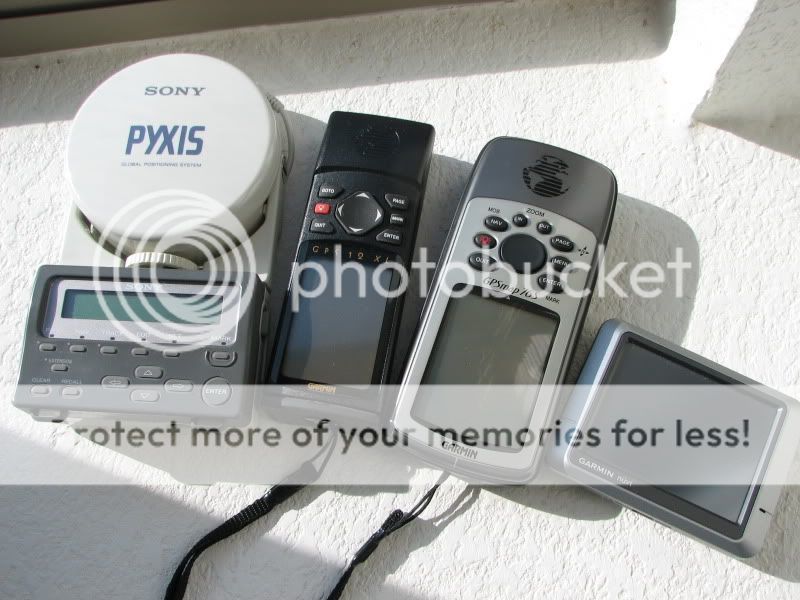
Just thought some of you guys might get a kick out of the Sony PYXIS, originally purchased way back in 1993! A couple of years later I picked up my first Garmin, the GPS38 which I sold unfortunately. It was revolutionary compared to the "digits only" navigation that was possible before. The GPS 12 XL was revolutionary in it's speed and was the first "fast" hand held. I still use it as a back up.


127.0.0.1
Flashlight Enthusiast
old thread, found this while searching for garmin edge 500
---
I ran a garmin nuvi, tomtom, and a magellan simultaneously for a week testing algorithms in middlesex county, massachusetts
bottom line. consistent fastest arrival time to destination was garmin over 15-20 mile routes, consistently 5 to 20 minutes
faster than tomtom or the magellan mapped out. garmin search algorithm works awesomely
Yes, old thread but I will say this since it still hold true for most (all of the cheaper and more common, and older TomTom models out there)....
There is no way to disable the auto-zoom feature on the TomTom units. That means you can be driving along or even stationary, and if you zoom out of the map to get a larger picture, it will not stay that way and will automatically zoom back into the map after a few seconds. It's extremely annoying when you want a specific map size showing on your GPS like when you're driving on the freeways, instead of a closeup of nearby side streets passing you by.
There is no way to disable the auto-zoom feature on the TomTom units. That means you can be driving along or even stationary, and if you zoom out of the map to get a larger picture, it will not stay that way and will automatically zoom back into the map after a few seconds. It's extremely annoying when you want a specific map size showing on your GPS like when you're driving on the freeways, instead of a closeup of nearby side streets passing you by.
Similar threads
- Replies
- 0
- Views
- 2K
